Sunday, August 21, 2005
07/25/05-07/26/05- Muncho Lake to Watson Lake
7/25/05 Monday through 7/26/05 Tuesday
Today we drove from Muncho Lake to Watson’s Lake. The distance was 169 miles. Our traveling buddies were C W and Sandi Greenwood. The are from Tallapossa, GA. The just got married back in December so this is kind of a honeymoon for them. C W is a HVAC contractor. I think he is about retired, but plans to continue to provide some repair services to his customers. We are going to the
Downtown RV Park in Watson’s Lake, and we will have a lay over day on Wednesday. That means two nights in the same place and a chance to catch up on some chores.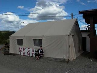
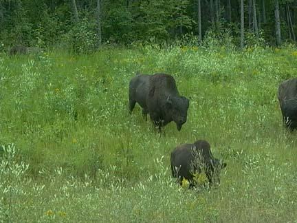
We had a pretty uneventful day. The only wildlife we saw was a couple of wild horses and a small herd of buffalo. There was not as much history on this section as yesterday. We crossed the Trout River soon after we left. Se followed it for a while and saw some pretty views from the mountains down into its valley. The Trout emptied into the Liard River system. The Liard seems to be the major river in the area. The Indians named, it and Laird in their language means BIG. It is a big stream. We crossed the Lower Laird Bridge first. It is notable that this is the last remaining suspension bridge left on the Alaska Highway.
We had to bypass a couple of things which Mary and I would have taken time to visit if we were traveling alone. First, was the Laird River Hot Springs. I would have enjoyed a good soak to break up the drive. The second was the Smith River Falls. There was a hike of about a mile and a half to get to the falls, so it would have taken a couple of hours to get there and get pictures. We passed on it. Maybe next time we can do it.
We crossed the Historic Contact Creek without knowing it. We did see the Contact Creek Lodge, which was the site of the planning to make the Southern end of the Highway meet up with the Northern end. I guess the site of their forest contact was Contact Creek. Shortly after this we stopped at Iron Creek Lodge for lunch. All these names have some significance to the construction of the Alaska Highway. Iron Creek was so named because this is where the trucks had to stop and put on chains before they could get up the next mountain.
We crossed over from British Columbia to The Yukon Territory. At this point Yukon Highway 1 joined our route. We traveled many miles along this strip of road, which stilled showed the effect of a fire in 1982. The fire burned down more than 400,000 acres of forest. It is still far from recovered from the damage.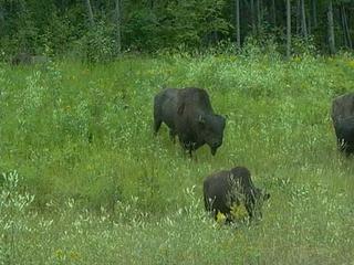
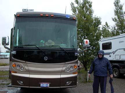
We got into our campground about 3:00. We got all set up and got ready for our day off. We had 30-amp electricity and even had free cable TV. I washed the RV and the car at their free RV Wash. It was a brush that fit on the end of a long water hose and required a lot of scrubbing on my part. but it was good to have it cleaned up. We had driven through a construction area that was completely unpaved and muddy.
On Tuesday, 7/26/05, we all went to the Sign Post Forest. Our Wagon Master had a sign made for the entire caravan and then anyone who had an individual sign could also put it up. There is, of course, a story about a homesick soldier putting a sign there with his name and hometown on it, back in 1943. It kind of developed into a tradition for travelers going up the Alaska Highway to put up a sign.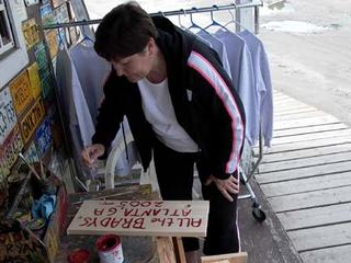 In 2004 a count was taken and there were more than 57,000 signs and they estimate that 2000+ are added each year. Mary and I didn’t have a sign, but we found a place there where we could get a piece of 1X8 about 18 inches long, paint and brush, and a hammer and two nails for $7.50. We made a sign and got someone to take a picture of us beside it.
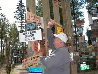
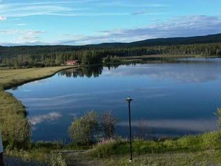
We saw a really nice presentation on the size of our universe followed by about a half hour on the Northern Lights. This was at the Northern Lights Theater. It is so comfortable lying back in those soft chairs looking up at the sky and listing to the soft piano music. I must admit that I dozed off for a few minutes. After we got back to the camp we had dinner in the Mess Tent. It literally was a tent. They took your order outside and cooked it in a separate little building, but you actually eat in a tent. We figured that we should not pass up a chance to eat in a mess tent while we were in the Yukon. Mary went out and walked around the lake with her camera after supper. She got nice pictures of the lake and some great wildflower shots.
We had a small problem, which we had to have help correcting. Our right turn signal stopped working on the car. It worked fine when the car was not hooked to the coach. The coach light worked fine, but it would not make the car signal work when they we connected. I got Billy, our technician, to check it out and with the help of Richard Mulford from Maine, he was able to rewire the head on the connecting cable and make it work. So now we are all set to go to Whitehorse, YT.
Today we drove from Muncho Lake to Watson’s Lake. The distance was 169 miles. Our traveling buddies were C W and Sandi Greenwood. The are from Tallapossa, GA. The just got married back in December so this is kind of a honeymoon for them. C W is a HVAC contractor. I think he is about retired, but plans to continue to provide some repair services to his customers. We are going to the
Downtown RV Park in Watson’s Lake, and we will have a lay over day on Wednesday. That means two nights in the same place and a chance to catch up on some chores.

We had a pretty uneventful day. The only wildlife we saw was a couple of wild horses and a small herd of buffalo. There was not as much history on this section as yesterday. We crossed the Trout River soon after we left. Se followed it for a while and saw some pretty views from the mountains down into its valley. The Trout emptied into the Liard River system. The Liard seems to be the major river in the area. The Indians named, it and Laird in their language means BIG. It is a big stream. We crossed the Lower Laird Bridge first. It is notable that this is the last remaining suspension bridge left on the Alaska Highway.

We had to bypass a couple of things which Mary and I would have taken time to visit if we were traveling alone. First, was the Laird River Hot Springs. I would have enjoyed a good soak to break up the drive. The second was the Smith River Falls. There was a hike of about a mile and a half to get to the falls, so it would have taken a couple of hours to get there and get pictures. We passed on it. Maybe next time we can do it.
We crossed the Historic Contact Creek without knowing it. We did see the Contact Creek Lodge, which was the site of the planning to make the Southern end of the Highway meet up with the Northern end. I guess the site of their forest contact was Contact Creek. Shortly after this we stopped at Iron Creek Lodge for lunch. All these names have some significance to the construction of the Alaska Highway. Iron Creek was so named because this is where the trucks had to stop and put on chains before they could get up the next mountain.
We crossed over from British Columbia to The Yukon Territory. At this point Yukon Highway 1 joined our route. We traveled many miles along this strip of road, which stilled showed the effect of a fire in 1982. The fire burned down more than 400,000 acres of forest. It is still far from recovered from the damage.
We got into our campground about 3:00. We got all set up and got ready for our day off. We had 30-amp electricity and even had free cable TV. I washed the RV and the car at their free RV Wash. It was a brush that fit on the end of a long water hose and required a lot of scrubbing on my part. but it was good to have it cleaned up. We had driven through a construction area that was completely unpaved and muddy.
On Tuesday, 7/26/05, we all went to the Sign Post Forest. Our Wagon Master had a sign made for the entire caravan and then anyone who had an individual sign could also put it up. There is, of course, a story about a homesick soldier putting a sign there with his name and hometown on it, back in 1943. It kind of developed into a tradition for travelers going up the Alaska Highway to put up a sign.
 In 2004 a count was taken and there were more than 57,000 signs and they estimate that 2000+ are added each year. Mary and I didn’t have a sign, but we found a place there where we could get a piece of 1X8 about 18 inches long, paint and brush, and a hammer and two nails for $7.50. We made a sign and got someone to take a picture of us beside it.
We saw a really nice presentation on the size of our universe followed by about a half hour on the Northern Lights. This was at the Northern Lights Theater. It is so comfortable lying back in those soft chairs looking up at the sky and listing to the soft piano music. I must admit that I dozed off for a few minutes. After we got back to the camp we had dinner in the Mess Tent. It literally was a tent. They took your order outside and cooked it in a separate little building, but you actually eat in a tent. We figured that we should not pass up a chance to eat in a mess tent while we were in the Yukon. Mary went out and walked around the lake with her camera after supper. She got nice pictures of the lake and some great wildflower shots.
We had a small problem, which we had to have help correcting. Our right turn signal stopped working on the car. It worked fine when the car was not hooked to the coach. The coach light worked fine, but it would not make the car signal work when they we connected. I got Billy, our technician, to check it out and with the help of Richard Mulford from Maine, he was able to rewire the head on the connecting cable and make it work. So now we are all set to go to Whitehorse, YT.
07/24/05-Sunday-Ft. Nelson to Muncho Lake
07/24/05 Sunday
Today we traveled from Fort Nelson to Muncho Lake where we stayed in the J&H Wilderness RV Park. The distance that we traveled was 164 miles. We traveled with Harry and Susan Bishop from New Jersey who are retired in Largo. They were in a short Class C motor home with a gas engine. Harry drove 45 mph tops and most of the time under 40 mph. We had six of our group, three groups of two, following us most of the day. The first group behind us made up the ten-minute lead that we were given in one hour. I’m glad we had such a short distance to travel.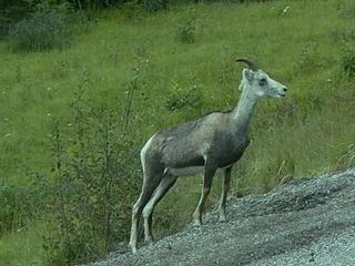
About two miles after we left the park where we spent the night, we crossed the Muskwa River Bridge at the southern edge of Fort Nelson. This bridge is the lowest spot on the Alaska Highway, at 1000 feet. Fort Nelson came into being as an outpost of the fur trading industry. First the Great Northwestern Fur Company and later The Hudson Bay Company owned the outpost. There is still a department store named Hudson Bay Company. The town was destroyed four times by Indians and by fire once. The fifth town is now the 300 mile pos t on the Alaska Highway. It is so primitive that they did not get mail service until 1936. Just north of Fort Nelson we passed the northern end of the North American Power Grid. There is no electricity. If a farm or home has power they have their own generator. Even the small towns have their own Diesel generating systems to provide electricity for their population.
There is little history of the Highway after you leave the Fort Nelson area. Most notable, would be the Lake Summit Pass that is the highest summit on the Highway at 4250 feet elevation. The drive between these two points is the most beautiful that we have seen in Canada. The mountain roads are good, but they have some steep grades, both up and down. Acc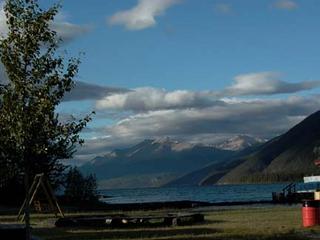 ording to the Milepost, the south-facing slopes of these mountains on the north side of the Muskwa River are a winter range for much of the wildlife in the area. Periodic control burns encourage the growth of grass and shrubs that are kept uncovered by the Chinook Winds so that the sheep, deer, elk, caribou, and moose can forage.
The Summit Lake area is in The Stone Mountain Provincial Park. This is the highest area of our trip. It has a lot of inns and lodges, as well as campgrounds, RV Parks and Guest Ranches. It is sparsely populated, but heavily used by tourists. This lake and Muncho Lake are both a part of a system of waterways including the Liard River and the Toad River. The Liard is the largest and we ran along with it for a lot of miles through the mountains.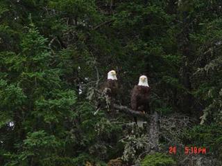
We stopped for lunch at the Toad River Lodge. The lodge had the largest collection of caps stuck to their ceiling that I have ever seen. You could tell that they catered to Rvers because on the top of the water tank on the toilet they had a Good Sam sticker that said “LET THE GOOD TIMES ROLL”. All of these places have large parking areas to accommodate RVs, but they are small inside. Our Asst. Wagon Master says they are one-skillet restaurants. He is about right; most can’t seat more than 20-25 people. This only about 50 miles from our campground at Muncho Lake, so we were there by about 1:30.
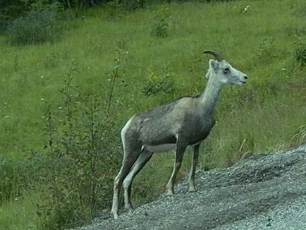
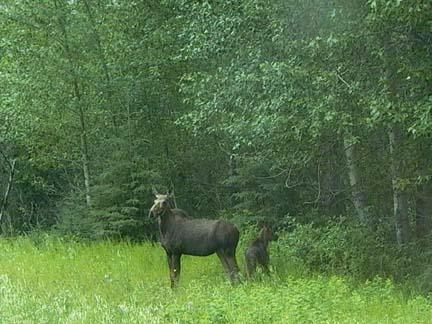
We saw a lot of wildlife on our trip today. Mary got some good pictures, and Sandi Greenwood from Tallapossa, GA shared some of her pictures with us as well. We saw several Stone Sheep and got pictures of individuals, as well as a small herd along side the road. We also saw several caribou. The best pictures we got were of a big bull and his mate. The guy had a huge rack of horns. We have seen moose before, but we never were able to get pictures. Mary got good pictures of a Momma Moose and her calf.
Our camping spot in Mu ncho Lake was right on the lake. The front of our coach was not more than thirty feet from the water. We only had 15 amp electricity and water. There was a dump station, but no sewer. The view was so great that we did not even mind. The mountains around the lake go up to 7000 feet. The deepest point in the lake is about 750 feet deep. The water temperature is about 47 degrees and it is so clear that you can see down into it a long way. We took a boat tour of the lake and the captain gave us more information than I can remember. Something that did stick in my mind is that the water in the lake is so pure that you can drink it. It has something to do with the mineral make up of the mountains. Also he told us that the mountains range on the west side of the lake is called the Terminal Mountains and that it is the northern terminus of the Rocky Mountains. So after we leave Muncho Lake there are no more Rocky Mountains.
The most spectacular thing that we saw today was a pair of Bald Eagles. We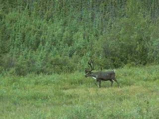 have great pictures of the two of them sitting on the same limb in a tree. They seemed to be posing for us. The captain said that they came looking for his boat when he did not have scheduled cruises.
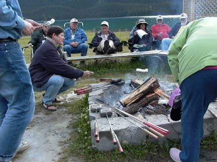
In the evening we had a campfire in a fire ring. We had a wiener roast and roasted marshmallows. The staff had pie irons. They provided bread, pie filling, or cheese if you wanted to make a grilled cheese sandwich. We stayed out there like a bunch of kids until a rain shower ran us inside.
It was a great day!!
Today we traveled from Fort Nelson to Muncho Lake where we stayed in the J&H Wilderness RV Park. The distance that we traveled was 164 miles. We traveled with Harry and Susan Bishop from New Jersey who are retired in Largo. They were in a short Class C motor home with a gas engine. Harry drove 45 mph tops and most of the time under 40 mph. We had six of our group, three groups of two, following us most of the day. The first group behind us made up the ten-minute lead that we were given in one hour. I’m glad we had such a short distance to travel.
About two miles after we left the park where we spent the night, we crossed the Muskwa River Bridge at the southern edge of Fort Nelson. This bridge is the lowest spot on the Alaska Highway, at 1000 feet. Fort Nelson came into being as an outpost of the fur trading industry. First the Great Northwestern Fur Company and later The Hudson Bay Company owned the outpost. There is still a department store named Hudson Bay Company. The town was destroyed four times by Indians and by fire once. The fifth town is now the 300 mile pos
 t on the Alaska Highway. It is so primitive that they did not get mail service until 1936. Just north of Fort Nelson we passed the northern end of the North American Power Grid. There is no electricity. If a farm or home has power they have their own generator. Even the small towns have their own Diesel generating systems to provide electricity for their population.
There is little history of the Highway after you leave the Fort Nelson area. Most notable, would be the Lake Summit Pass that is the highest summit on the Highway at 4250 feet elevation. The drive between these two points is the most beautiful that we have seen in Canada. The mountain roads are good, but they have some steep grades, both up and down. Acc
 ording to the Milepost, the south-facing slopes of these mountains on the north side of the Muskwa River are a winter range for much of the wildlife in the area. Periodic control burns encourage the growth of grass and shrubs that are kept uncovered by the Chinook Winds so that the sheep, deer, elk, caribou, and moose can forage.
The Summit Lake area is in The Stone Mountain Provincial Park. This is the highest area of our trip. It has a lot of inns and lodges, as well as campgrounds, RV Parks and Guest Ranches. It is sparsely populated, but heavily used by tourists. This lake and Muncho Lake are both a part of a system of waterways including the Liard River and the Toad River. The Liard is the largest and we ran along with it for a lot of miles through the mountains.

We stopped for lunch at the Toad River Lodge. The lodge had the largest collection of caps stuck to their ceiling that I have ever seen. You could tell that they catered to Rvers because on the top of the water tank on the toilet they had a Good Sam sticker that said “LET THE GOOD TIMES ROLL”. All of these places have large parking areas to accommodate
 RVs, but they are small inside. Our Asst. Wagon Master says they are one-skillet restaurants. He is about right; most can’t seat more than 20-25 people. This only about 50 miles from our campground at Muncho Lake, so we were there by about 1:30.
We saw a lot of wildlife on our trip today. Mary got some good pictures, and Sandi Greenwood from Tallapossa, GA shared some of her pictures with us as well. We saw several Stone Sheep and got pictures of individuals, as well as a small herd along side the road. We also saw several caribou. The best pictures we got were of a big bull and his mate. The guy had a huge rack of horns. We have seen moose before, but we never were able to get pictures. Mary got good pictures of a Momma Moose and her calf.
Our camping spot in Mu
 ncho Lake was right on the lake. The front of our coach was not more than thirty feet from the water. We only had 15 amp electricity and water. There was a dump station, but no sewer. The view was so great that we did not even mind. The mountains around the lake go up to 7000 feet. The deepest point in the lake is about 750 feet deep. The water temperature is about 47 degrees and it is so clear that you can see down into it a long way. We took a boat tour of the lake and the captain gave us more information than I can remember. Something that did stick in my mind is that the water in the lake is so pure that you can drink it. It has something to do with the mineral make up of the mountains. Also he told us that the mountains range on the west side of the lake is called the Terminal Mountains and that it is the northern terminus of the Rocky Mountains. So after we leave Muncho Lake there are no more Rocky Mountains.
The most spectacular thing that we saw today was a pair of Bald Eagles. We
 have great pictures of the two of them sitting on the same limb in a tree. They seemed to be posing for us. The captain said that they came looking for his boat when he did not have scheduled cruises.
In the evening we had a campfire in a fire ring. We had a wiener roast and roasted marshmallows. The staff had pie irons. They provided bread, pie filling, or cheese if you wanted to make a grilled cheese sandwich. We stayed out there like a bunch of kids until a rain shower ran us inside.
It was a great day!!
07/23/05- Dawson Creek to Ft. Nelson
07/23/05 Saturday
We left Dawson Creek this morning in the rain. Our first day was 276 miles to Fort Nelson. Our travel buddies were Ma rv and Doris Cundiff from Louisville, KY. They are living now in Sarasota, FL and own a Real Estate business, which their Son is now running. Marv is a real estate auctioneer. They recently lost their daughter and their son is their only remaining child. They led and we followed and we were in radio contact, as we needed to be. Marv had a sharp eye and he found a lot of wild life for Mary to take pictures of.
We saw a lot of the history of the Alaska Highway and will continue as we go. The highway runs from Dawson Creek, BC to Delta Junction, AK, and the distance is 1390 miles. The time of construction was about nine months and later it was declared the 16th most impressive engineering feat in history. It was built by Canada and the US as a means of moving the military to defend Canada and Alaska after Japan attacked Pearl Harbor and the n occupied one of the Aleutian Islands. The military also strung phone lines along the highway and to areas that paralleled it. They named it Cantel and in all it consisted of 2850 miles of open telephone line, one of the longest open circuit systems in the world. It served 1600 army telephones and teletypes and required a series of “repeater stations” which boosted to signal and kept the messages moving along. We saw a sign for the first of these repeater stations north of Dawson Creek. We also saw a sign for, but did not go to see the last timber bridge in existence on the road. It spans the Kiskatiinaw River and is 162 Meters long. The road has been re-routed in many places during improvement and it left the bridge in an unused loop of gravel road.
One of the interesting towns, which we went through, was Taylor. Duke Energy Inc. has a natural gas processing plant there. One of the major by products of gas processing is sulfur. They pipe the sulfur in gas form across the road to another plant that converts it to pellet form for commercial distribution. They also have a natural gas pipeline that we saw and have a picture of, which goes to Vancouver and Western Washington. Taylor also has a saw mill and pulp mill.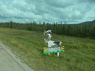
We had lunch at the Shepherd’s Inn and it was full of people from our caravan. We ate at a long table and must have had 10 or 12 people. The only unusual food I saw was something called Trapper’s Bannock. It was a fried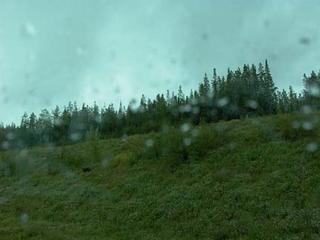 biscuit about three inches thick and the size of a plate. The served it with all the jam you wanted. Several of us sampled it.
We saw a lot of really neat signs. They had caution signs of all the animals with the shape of the animal built into it. We saw sign for a sawmill that was a lumberjack about 30 feet tall. We saw beautiful forests with large stands of white Birch trees. They are so tall and straight.
The kind of wild life that we saw was deer, caribou and black bear. We had never seen a caribou or bear in the wild. Mary got pictures of both, but she got buck fever on the bear. She grabbed her camera and shot three pictures before she realized that she had not zoomed up for the closest picture. He kind of looks like a black speck in the high green grass.
After we got to Fort Nelson and were in our campground, Mary walked down the street to a place called Trapper’s Den. She had a great visit with the lady there who owned it with her family. She got a lot of history of the area and the type of hunting and trapping they did. She did not buy anything because even though the crafts were excellent they were very expensive.
We left Dawson Creek this morning in the rain. Our first day was 276 miles to Fort Nelson. Our travel buddies were Ma
 rv and Doris Cundiff from Louisville, KY. They are living now in Sarasota, FL and own a Real Estate business, which their Son is now running. Marv is a real estate auctioneer. They recently lost their daughter and their son is their only remaining child. They led and we followed and we were in radio contact, as we needed to be. Marv had a sharp eye and he found a lot of wild life for Mary to take pictures of.
We saw a lot of the history of the Alaska Highway and will continue as we go. The highway runs from Dawson Creek, BC to Delta Junction, AK, and the distance is 1390 miles. The time of construction was about nine months and later it was declared the 16th most impressive engineering feat in history. It was built by Canada and the US as a means of moving the military to defend Canada and Alaska after Japan attacked Pearl Harbor and the
 n occupied one of the Aleutian Islands. The military also strung phone lines along the highway and to areas that paralleled it. They named it Cantel and in all it consisted of 2850 miles of open telephone line, one of the longest open circuit systems in the world. It served 1600 army telephones and teletypes and required a series of “repeater stations” which boosted to signal and kept the messages moving along. We saw a sign for the first of these repeater stations north of Dawson Creek. We also saw a sign for, but did not go to see the last timber bridge in existence on the road. It spans the Kiskatiinaw River and is 162 Meters long. The road has been re-routed in many places during improvement and it left the bridge in an unused loop of gravel road.
One of the interesting towns, which we went through, was Taylor. Duke Energy Inc. has a natural gas processing plant there. One of the major by products of gas processing is sulfur. They pipe the sulfur in gas form across the road to another plant that converts it to pellet form for commercial distribution. They also have a natural gas pipeline that we saw and have a picture of, which goes to Vancouver and Western Washington. Taylor also has a saw mill and pulp mill.

We had lunch at the Shepherd’s Inn and it was full of people from our caravan. We ate at a long table and must have had 10 or 12 people. The only unusual food I saw was something called Trapper’s Bannock. It was a fried
 biscuit about three inches thick and the size of a plate. The served it with all the jam you wanted. Several of us sampled it.
We saw a lot of really neat signs. They had caution signs of all the animals with the shape of the animal built into it. We saw sign for a sawmill that was a lumberjack about 30 feet tall. We saw beautiful forests with large stands of white Birch trees. They are so tall and straight.
The kind of wild life that we saw was deer, caribou and black bear. We had never seen a caribou or bear in the wild. Mary got pictures of both, but she got buck fever on the
 bear. She grabbed her camera and shot three pictures before she realized that she had not zoomed up for the closest picture. He kind of looks like a black speck in the high green grass.
After we got to Fort Nelson and were in our campground, Mary walked down the street to a place called Trapper’s Den. She had a great visit with the lady there who owned it with her family. She got a lot of history of the area and the type of hunting and trapping they did. She did not buy anything because even though the crafts were excellent they were very expensive.
![]()