Monday, August 29, 2005
08/25/05 Thursday through 08/27/05 Saturday - Palmer to Valdez
 08/25/05 Thursday through 08/27/05 Saturday
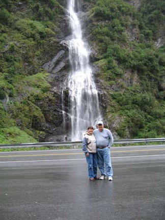
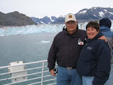
We are in Valdez. We left Palmer at 8:10 AM and arrived here about 2:30 PM. Our traveling buddies today were Bill and Francy Garrett. From Coral Springs, FL. Francy has been over to our house two different times since we got set up trying to get some pictures copied. She had a lot of pictures of us and our Motor Home, which she wanted to give to us. She can’t figure out how to copy them to a CD. We traveled about 260 miles and we had a lot of rain. We passed through beautiful mountains with a lot of glaciers and some beautiful waterfalls. The road was really bad for about the first 50 miles. It was really up and down and lots of curves. The permafrost had pushed it up and there were a lot of what they call ground swells. There were no shoulders on a lot of it and no guard rails either. I was glad to get off of that stretch of road.
We followed the Matanuska River for a long way. It offered some really pretty views and Mary got good pictures from the tall bluffs we traveled which dropped down to the river valley. We saw a glacier by the same name as the river. It is thought to have remained stable for the last 400 years. This is unusual because most are receding. We stayed on Alaska Hwy 1 all the way to Glennallen, AK. We stopped in Glennallen at the Caribou Hotel and had lunch. We were the first of our group to get there for lunch, but by the time we left there were about ten RV’s in the parking lot.
At Glennallen we turned south on Hwy 4 and went 117 miles to Valdez. We ran alongside the Alaska Pipeline most of the pay. It wasn’t visible often because most of the way it was underground. There was a really pretty little river that followed the road for a long distance. We crossed it several times. It is the Tazlina River, which means swift water in the local Indian dialect.
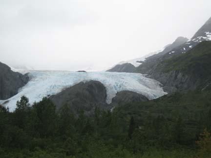
We saw three major glaciers on the road the biggest was Worthington Glacier. We have wonderful pictures of this glacier. We also got some great pictures of Thompson Pass that is the highest point on the highway. This pass has the record for snowfall in Alaska. All these records were set in the 1950’s. In 1952-53 they recorded 974.5 inches of snow for the season. In 1953 the recorded 298 inches of snow during the month of February and in December 1955, they recorded 62 inches of snow in a 24-hour period. The had snow poles which were probably 12 feet high with a ninety degree angle at the top painted yellow. These lined both sides of the road to serve as guides for snowplows to keep them on the road. Coming down from the pass you pass through Keystone Canyon where we got pictures of two waterfalls. They were Bridal Veil, and Horse Tail. We have great pictures of both. We got to Bear Paw RV Park at 2:30 and we were the first group to arrive, which is a first They allow us to wash our vehicles and I did the bikes, car and part of the coach. I’ll try to finish up tomorrow after our tour.

On Friday Aug 26th we boarded a boat for a 10-hour tour of Prince William Sound to see the fjords, glaciers and the wildlife of the area. I was really worried about the weather when we started. The weather channel was forecasting a 70 percent chance for rain. It wasn’t raining, but the fog was right down on the water. The captain was going real slowly and he kept blowing his horn, which I assumed was to announce our position to other boats that couldn’t see us. We took a cruise like this last week so we kind of knew what to expect. Right away we noticed a few things that were different. The boat was a big catamaran and the ride was much smoother. The captain was a lot more laid back, and as the
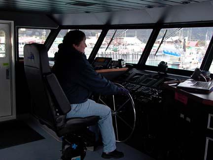 day progressed he invited anyone who was interested to come into the wheelhouse and see how the ship worked. I think he had someone in there most of the day. Mary took a picture of everything up there. She may not know how it works, but she knows what it looks like.
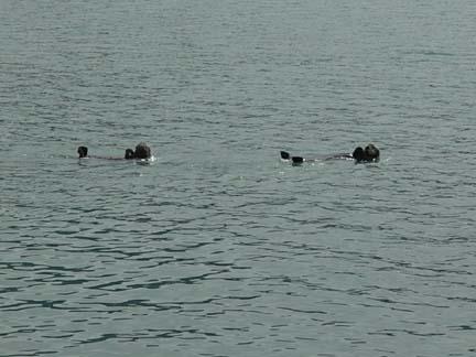
We didn’t see any wildlife today, which we didn’t see on our last cruise except a Black Bear. There was a small beach running along the bottom of a wooded hillside and he was out of the beach catching fish. Mary got a few pictures of him but he was so far away it is hard to see him. I had a good look at him with my binoculars and he was a big one. He went into the bushes once with his fish, and turned around and came back out and got another on which he had left. We had three real good looks at him.

We saw several Bald Eagles and got some decent pictures of them. In the information we were told about the eagles, the captain said that there were 2500 pairs of Bald Eagles that live in the area. The mate for life and tend to return to the same nest year after year and keep repairing it and making it bigger. Sometimes a next can, after years of use, weigh as much as 2000 pounds and be as big as a car. All the other birds we saw we had seen last week. I was amazed by two birds who caught up with the boat as we were cruising at a speed which the captain said was about 21 MPH. The birds called Black-Legged Kittiwak
 es caught with us and flew alongside the boat at that speed for about 10 minutes. It must have been three or more miles that we were side by side. We had to slow down because of the ice chunks from the glacier and they just left us.
The highlight of the trip was seeing Columbia Glacier. Columbia is the second fastest receding glacier in North America. The captain told us that the front wall of ice is between 300 and 500 feet high above water, and goes down 800-1200 feet under water. We started to see ice chunks from it about 15 miles away and as we got closer to the glacier they became bigger and closer together. The captain said that sometimes there was an ice jam as far out as 25 miles when the glacier was really calving of the chunks of ice.
 Today was a slow day of calving and we were able to get within about a mile and a half of the leading edge of the ice. The average is about thirteen million tons of ice breaking of the glacier each day. That is hard for me to grasp.
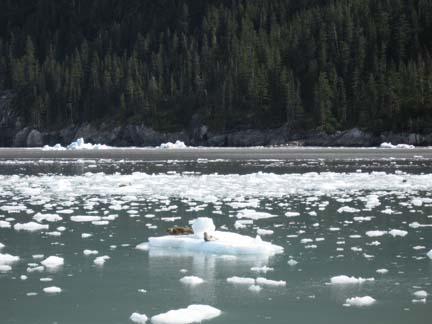 Most glaciers are receding and will someday be gone. We did see another glacier that was at the other end of the spectrum. Mears Glacier is much younger and is still growing instead of retreating. It is only about two miles wide and 200 feet high with only about 50 feet under water. There was a lot of ice in the water in front of Mears Glacier. We were able to get within a quarter of a mile of the wall so we got good views of it. We also got a lot of good views of Harbor Seals on the floating ice chunks. The just lay up there in the sun and posed for our cameras.
On the way back into port we went through the area where the big oil spill occurred back in the late 1980’s. He gave us some facts about it, which I’m not sure that I understand. What I did get from his speech is that tankers are supposed to be better now so that won’t happen again. However, the company has all kind of recovery and cleanup equipment and personnel on standby and getting ongoing training just in case.
On Saturday Aug 27th we didn’t have a planned activity until 2:00 PM when we went on a tour of Valdez and the surrounding area. I spent the morning working on the Internet and Mary went shopping. On our tour we saw the terminal for the Alaska Pipeline. It is really quite elaborate the way the oil is stored and transferred to the tankers for shipping. Today only about one million barrels of oil a day pass through Valdez. Twenty years ago it was two million. The have eighteen tanks that combined hold 1.9 million gallons of oil that is the amount that the pipeline will hold so if there is ever a need the pumps can be shut down and the line emptied into the tanks. Oil from the tanks is loaded onto the tankers, but some oil is pumped directly form the pipeline into the tankers. We the decreased flow of oil they only load at two of the five births. There is a refinery a few miles above the terminal. It draws oil directly from the pipe takes what it needs for it production and returns the leftovers back into the pipeline to continue to the terminal
We also saw their fish hatchery and some spawning streams for salmon. We saw them swimming upstream where they would spawn and die. At the point we were looking at the stream it was less than a foot deep and the fish were fighting each other for space to continue upstream.
 They have some method of capturing the fish and harvesting the eggs and the sperm and growing the babies in trays and releasing them back into the water. The salmon fishing industry almost died before the fishermen sent together and started the hatcheries to protect the salmon crop.
We visited the site of the old town of Valdez, which was destroyed by an earthquake in 1964. The quake did a lot of damage all along the west coast of Alaska. We saw a lot of signs of it as far north as Nome. Today Valdez has a population of about 4500. Its main industry is fishing, along with a good deep-water port. It is the Northern most ice free port in North America. Of course, the pipeline brings in about 75 oil tankers a month as well.
![]()