Sunday, August 21, 2005
07/24/05-Sunday-Ft. Nelson to Muncho Lake
07/24/05 Sunday
Today we traveled from Fort Nelson to Muncho Lake where we stayed in the J&H Wilderness RV Park. The distance that we traveled was 164 miles. We traveled with Harry and Susan Bishop from New Jersey who are retired in Largo. They were in a short Class C motor home with a gas engine. Harry drove 45 mph tops and most of the time under 40 mph. We had six of our group, three groups of two, following us most of the day. The first group behind us made up the ten-minute lead that we were given in one hour. I’m glad we had such a short distance to travel.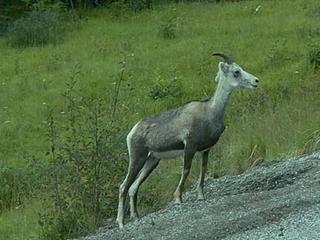
About two miles after we left the park where we spent the night, we crossed the Muskwa River Bridge at the southern edge of Fort Nelson. This bridge is the lowest spot on the Alaska Highway, at 1000 feet. Fort Nelson came into being as an outpost of the fur trading industry. First the Great Northwestern Fur Company and later The Hudson Bay Company owned the outpost. There is still a department store named Hudson Bay Company. The town was destroyed four times by Indians and by fire once. The fifth town is now the 300 mile pos t on the Alaska Highway. It is so primitive that they did not get mail service until 1936. Just north of Fort Nelson we passed the northern end of the North American Power Grid. There is no electricity. If a farm or home has power they have their own generator. Even the small towns have their own Diesel generating systems to provide electricity for their population.
There is little history of the Highway after you leave the Fort Nelson area. Most notable, would be the Lake Summit Pass that is the highest summit on the Highway at 4250 feet elevation. The drive between these two points is the most beautiful that we have seen in Canada. The mountain roads are good, but they have some steep grades, both up and down. Acc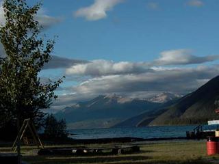 ording to the Milepost, the south-facing slopes of these mountains on the north side of the Muskwa River are a winter range for much of the wildlife in the area. Periodic control burns encourage the growth of grass and shrubs that are kept uncovered by the Chinook Winds so that the sheep, deer, elk, caribou, and moose can forage.
The Summit Lake area is in The Stone Mountain Provincial Park. This is the highest area of our trip. It has a lot of inns and lodges, as well as campgrounds, RV Parks and Guest Ranches. It is sparsely populated, but heavily used by tourists. This lake and Muncho Lake are both a part of a system of waterways including the Liard River and the Toad River. The Liard is the largest and we ran along with it for a lot of miles through the mountains.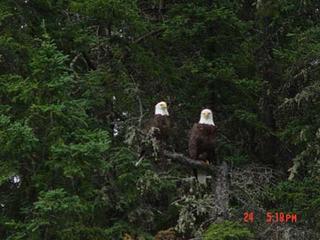
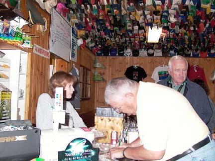
We stopped for lunch at the Toad River Lodge. The lodge had the largest collection of caps stuck to their ceiling that I have ever seen. You could tell that they catered to Rvers because on the top of the water tank on the toilet they had a Good Sam sticker that said “LET THE GOOD TIMES ROLL”. All of these places have large parking areas to accommodate RVs, but they are small inside. Our Asst. Wagon Master says they are one-skillet restaurants. He is about right; most can’t seat more than 20-25 people. This only about 50 miles from our campground at Muncho Lake, so we were there by about 1:30.
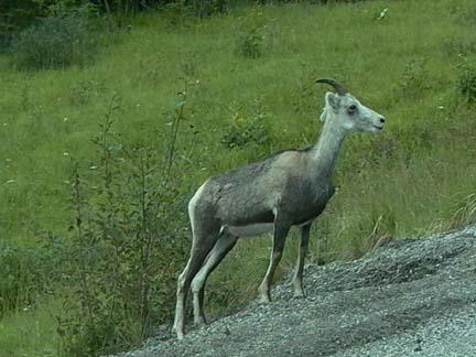
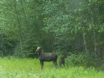
We saw a lot of wildlife on our trip today. Mary got some good pictures, and Sandi Greenwood from Tallapossa, GA shared some of her pictures with us as well. We saw several Stone Sheep and got pictures of individuals, as well as a small herd along side the road. We also saw several caribou. The best pictures we got were of a big bull and his mate. The guy had a huge rack of horns. We have seen moose before, but we never were able to get pictures. Mary got good pictures of a Momma Moose and her calf.
Our camping spot in Mu ncho Lake was right on the lake. The front of our coach was not more than thirty feet from the water. We only had 15 amp electricity and water. There was a dump station, but no sewer. The view was so great that we did not even mind. The mountains around the lake go up to 7000 feet. The deepest point in the lake is about 750 feet deep. The water temperature is about 47 degrees and it is so clear that you can see down into it a long way. We took a boat tour of the lake and the captain gave us more information than I can remember. Something that did stick in my mind is that the water in the lake is so pure that you can drink it. It has something to do with the mineral make up of the mountains. Also he told us that the mountains range on the west side of the lake is called the Terminal Mountains and that it is the northern terminus of the Rocky Mountains. So after we leave Muncho Lake there are no more Rocky Mountains.
The most spectacular thing that we saw today was a pair of Bald Eagles. We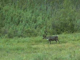 have great pictures of the two of them sitting on the same limb in a tree. They seemed to be posing for us. The captain said that they came looking for his boat when he did not have scheduled cruises.
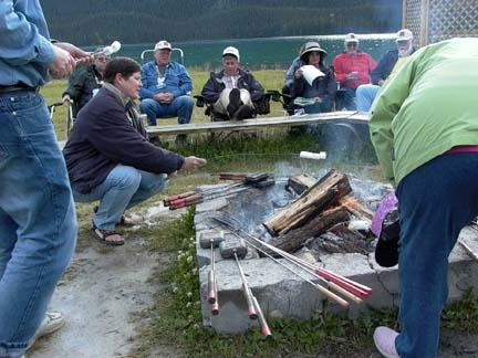
In the evening we had a campfire in a fire ring. We had a wiener roast and roasted marshmallows. The staff had pie irons. They provided bread, pie filling, or cheese if you wanted to make a grilled cheese sandwich. We stayed out there like a bunch of kids until a rain shower ran us inside.
It was a great day!!
Today we traveled from Fort Nelson to Muncho Lake where we stayed in the J&H Wilderness RV Park. The distance that we traveled was 164 miles. We traveled with Harry and Susan Bishop from New Jersey who are retired in Largo. They were in a short Class C motor home with a gas engine. Harry drove 45 mph tops and most of the time under 40 mph. We had six of our group, three groups of two, following us most of the day. The first group behind us made up the ten-minute lead that we were given in one hour. I’m glad we had such a short distance to travel.
About two miles after we left the park where we spent the night, we crossed the Muskwa River Bridge at the southern edge of Fort Nelson. This bridge is the lowest spot on the Alaska Highway, at 1000 feet. Fort Nelson came into being as an outpost of the fur trading industry. First the Great Northwestern Fur Company and later The Hudson Bay Company owned the outpost. There is still a department store named Hudson Bay Company. The town was destroyed four times by Indians and by fire once. The fifth town is now the 300 mile pos
 t on the Alaska Highway. It is so primitive that they did not get mail service until 1936. Just north of Fort Nelson we passed the northern end of the North American Power Grid. There is no electricity. If a farm or home has power they have their own generator. Even the small towns have their own Diesel generating systems to provide electricity for their population.
There is little history of the Highway after you leave the Fort Nelson area. Most notable, would be the Lake Summit Pass that is the highest summit on the Highway at 4250 feet elevation. The drive between these two points is the most beautiful that we have seen in Canada. The mountain roads are good, but they have some steep grades, both up and down. Acc
 ording to the Milepost, the south-facing slopes of these mountains on the north side of the Muskwa River are a winter range for much of the wildlife in the area. Periodic control burns encourage the growth of grass and shrubs that are kept uncovered by the Chinook Winds so that the sheep, deer, elk, caribou, and moose can forage.
The Summit Lake area is in The Stone Mountain Provincial Park. This is the highest area of our trip. It has a lot of inns and lodges, as well as campgrounds, RV Parks and Guest Ranches. It is sparsely populated, but heavily used by tourists. This lake and Muncho Lake are both a part of a system of waterways including the Liard River and the Toad River. The Liard is the largest and we ran along with it for a lot of miles through the mountains.

We stopped for lunch at the Toad River Lodge. The lodge had the largest collection of caps stuck to their ceiling that I have ever seen. You could tell that they catered to Rvers because on the top of the water tank on the toilet they had a Good Sam sticker that said “LET THE GOOD TIMES ROLL”. All of these places have large parking areas to accommodate
 RVs, but they are small inside. Our Asst. Wagon Master says they are one-skillet restaurants. He is about right; most can’t seat more than 20-25 people. This only about 50 miles from our campground at Muncho Lake, so we were there by about 1:30.
We saw a lot of wildlife on our trip today. Mary got some good pictures, and Sandi Greenwood from Tallapossa, GA shared some of her pictures with us as well. We saw several Stone Sheep and got pictures of individuals, as well as a small herd along side the road. We also saw several caribou. The best pictures we got were of a big bull and his mate. The guy had a huge rack of horns. We have seen moose before, but we never were able to get pictures. Mary got good pictures of a Momma Moose and her calf.
Our camping spot in Mu
 ncho Lake was right on the lake. The front of our coach was not more than thirty feet from the water. We only had 15 amp electricity and water. There was a dump station, but no sewer. The view was so great that we did not even mind. The mountains around the lake go up to 7000 feet. The deepest point in the lake is about 750 feet deep. The water temperature is about 47 degrees and it is so clear that you can see down into it a long way. We took a boat tour of the lake and the captain gave us more information than I can remember. Something that did stick in my mind is that the water in the lake is so pure that you can drink it. It has something to do with the mineral make up of the mountains. Also he told us that the mountains range on the west side of the lake is called the Terminal Mountains and that it is the northern terminus of the Rocky Mountains. So after we leave Muncho Lake there are no more Rocky Mountains.
The most spectacular thing that we saw today was a pair of Bald Eagles. We
 have great pictures of the two of them sitting on the same limb in a tree. They seemed to be posing for us. The captain said that they came looking for his boat when he did not have scheduled cruises.
In the evening we had a campfire in a fire ring. We had a wiener roast and roasted marshmallows. The staff had pie irons. They provided bread, pie filling, or cheese if you wanted to make a grilled cheese sandwich. We stayed out there like a bunch of kids until a rain shower ran us inside.
It was a great day!!
![]()