Thursday, September 08, 2005
09/02/05 Friday - Watson's Lake to Iskut
 09/02/05 Friday
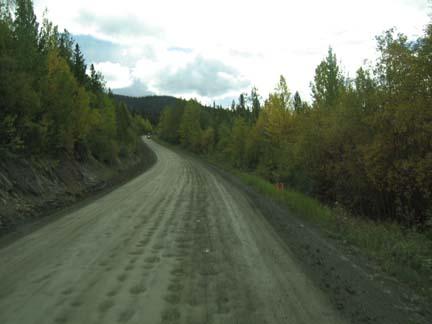
Today we left the Alaska Highway and began our trip over the Cassair Hwy. We traveled with Billie and Jaye Lundrigan. Billie is our “Tail Gunner”; he always goes last and helps anyone who has trouble on the road. He is a factory trained service technician and can do most things to keep everyone going. He had to help us once. Some of our lights quit working on the car when it was hooked to the coach. He rewired the electrical cable that goes from the coach to the front of the car. It took a little trial and error to get the wires all connected to the proper posts, but he did it. We left the park at 9:15 AM and of course everyone else was already gone.
The Cassiar Highway was completed in 1972 to connect Yellowhead Hiighway with Alaska. If you are traveling to Prince George, British Columbia, which we are, you can save about 130 miles taking the Cassiar instead of the Alaska Highway. We traveled through some small mountains called the Cassiar Mountains during the early morning. We came to higher more scenic mountains called the Horse-ranch Mountains. They are the oldest Mountains in Northern British Columbia. There are a lot of different types of mining in the area.
 The Cassiar Gold Strike produced a lot of gold in the 1870’s. A miner named Alfred Freeman found an all gold nugget (no quartz) that weighed 72 ounces. This was in 1877 and it is still the largest all gold nugget ever found in British Columbia. There is still active goal mining in the area. The most profitable mining taking place now is jade. Canada produces several different kinds and quality of jade. In fact, the Cassiar Mountains provide about seventy five percent of the worlds jade supply. The latest and most valuable is Artic Jade, it is a favorite for jewelry making. Mary bought a small piece of it to make jewelry in her classes this winter. Now there are basically two stores that sell the raw jade and actually have artist there who make items to sell. They are in Jade City. It used to be a town, but now the two stores are all that is left.
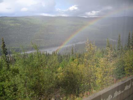
We crossed the Stikine River Bridge in a rain shower. The Stikine is an Indian word that means “Great River”, and it is. We went downhill for five kilometers before we got to the river. When we climbed out of the canyon Mary tried to look back and see the river in the distant bottom. I don’t think she saw the river, but she saw a beautiful rainbow and got a picture of it.
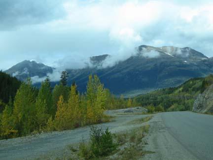
 We did not see Mount Edziza because it was covered by clouds and fog, bit it is 9,143 feet tall and is a dormant volcano. I believe that you are able to see the lava flow paths from the highway. It is in a wilderness park that has no road access.
We are staying in Tatogga Lake Resort and RV Park. It is on one of the many lakes that we passed today. The lakes are huge and all connected by streams and rivers that make it possible to travel from one to the other. This makes it possible to go great distances in Canada and Alaska on water. I thought we were going to need a boat while we were setting up. It rained a lot and it rained a lot on us as we traveled today. We were on a lot of gravel and dirt roads so our rig is a mess. I hate to even touch it. I’m not sure how long it will be before we get to a place to clean up.
 We are about ten miles from Iskut, a small Tahltan Indian town with 283 population. The park has an electrical system that runs off a diesel generator. We don’t have enough power to run everything we need. I unhooked and we are using our generator and inverter to provide our electricity. We still don’t have cell phone service and tonight we have no Internet access. We miss the conveniences, but we love the wilderness. Mary thought today was the prettiest scenery we have seen on the entire trip.
![]()