Saturday, August 27, 2005
08/02/05 Tuesday- Dawson City to Tok
08/02/05 Tuesday
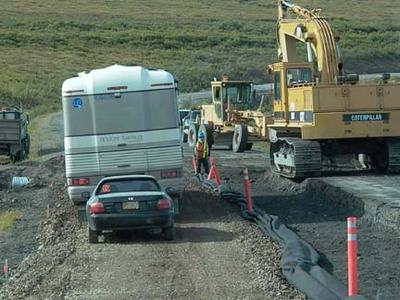
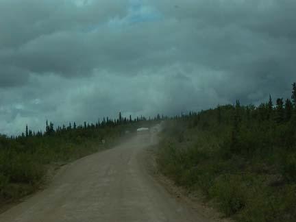
Today we finish the Klondike Loop and drive over the toughest road that we will encounter of the trip. We are going from Dawson City, YT to Tok, AK. The trip is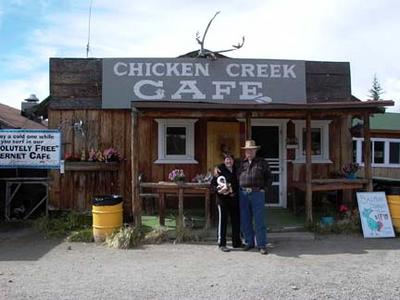 only about 185 miles, but it took us nearly nine hours, including all our stops. We traveled with Ed and Karlene Spivak from Placitas, NM. The Klondike Loop began where we left the Alaska Highway just north of Whitehorse. We drove 322 miles on Yukon Highway 2 to get to Dawson City. The part of the Loop that remains is Hwy 9 from Dawson City to Jack Wade Junction, which is called the Top of the World Highway, and then 85 miles on the Taylor Highway. Taylor gets us back to the Alaska Highway about 12 miles south of Tok, Alaska. Taylor Highway was pretty uneventful, but the Top of the World was something else. I am only estimating, but somewhere between 50 and 70 miles of this highway is either dirt or gravel. It had not rained in a while so there was a lot of dust. The road was very narrow and rough. In some places we drove on ridges where the land dropped away on both sides of the road into deep valleys. There were no guardrails. The views were truly awe-inspiring.
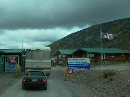
 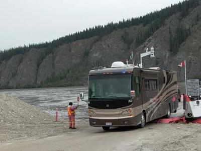 It was not so much the dramatic high peaks and snowcaps that you envision, but it was vast mountain ranges that went as far as you could see in any direction. The highest summit was 4515 feet. We crossed it about a mile south of the border crossing. We crossed into the United States at Poker Creek Border Crossing, which is the Northern most land border entry into the United States. The crossing, thus the Top of the World Highway is open from mid-May until the end of September. It is so isolated there that I’m sure that the people who work there must live there for the months which it is open. Several of our group really complained about this part of our trip. I would not have passed it up for anything, even though we did have four rock chips in our windshields to get repaired. We also spent three hours washing on our car and motor home. We got a lot of pictures, but they could never do justice to the view we had from this drive.
I’ inserting this as an afterthought. It really was one of the highlights of the day. We started our trip with a ferry crossing of the Yukon River. I guess the river was between a quarter and a half mile wide. The ferry would only hold two RV’s at most. It took us about three hours to make the crossing, so we were really spread out in this days travel. It was kink of tense driving that big vehicle onto and off of the boat.
Once we reached Jack Wade Junction, we had 96 miles to Tok. Eighty- five of those miles were on the Taylor Highway, which worked its way down out of the mountains into a huge valley where Tok is located. Took originated as a work camp for the construction of the Alaska Highway. I think that one of its major industries now is dogs. I guess they raise, train and race led dogs. It is a small town and the dog population is about double the Human population.

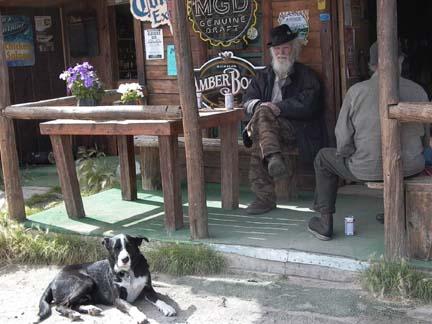
Our first town after we got into Alaska was Chicken. The miners who founded Chicken wanted to name it Ptarmigan, but they did not know how to spell that so they settled for Chicken, which in the North is a common name for Ptarmigan. Chicken’s most famous citizen was Ann Purdy, who wrote a book entitled TISHA. It was about her life in Chicken as a young schoolteacher. We did not buy the book but some of our group did. I guess it is quite entertaining .
.
In the area of Chicken, there was gold discovered before the strikes in the Klondike. In 1895 the first strike in this area was make in Franklin Gulch on Fortymile River. The Lost Chicken Hill Mine on Chicken Creek is on of those early strikes. While traveling through this area and for many miles West of Chicken we drove through a burn area where 1.3 million acres burned in 2004. Our Wagon Master said they saw the fire when they passed through here last year. We saw some fires in the mountains along the border this morning.
After Chicken, the Taylor Highway is mostly straight, downhill and well paved. I really made up for our slow climbing drive of the morning. For a lot of the trip we probably got between 12 and 15 mpg on our fuel. We got to the Tok RV Village and found good wide pull-through sites with 30-amp electricity, good water and sewer. We had cable and Y_FI, which we did not use because it was $8.95 for the night. We will just wait until we get to Fairbanks.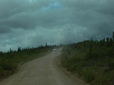
Today we finish the Klondike Loop and drive over the toughest road that we will encounter of the trip. We are going from Dawson City, YT to Tok, AK. The trip is
 only about 185 miles, but it took us nearly nine hours, including all our stops. We traveled with Ed and Karlene Spivak from Placitas, NM. The Klondike Loop began where we left the Alaska Highway just north of Whitehorse. We drove 322 miles on Yukon Highway 2 to get to Dawson City. The part of the Loop that remains is Hwy 9 from Dawson City to Jack Wade Junction, which is called the Top of the World Highway, and then 85 miles on the Taylor Highway. Taylor gets us back to the Alaska Highway about 12 miles south of Tok, Alaska. Taylor Highway was pretty uneventful, but the Top of the World was something else. I am only estimating, but somewhere between 50 and 70 miles of this highway is either dirt or gravel. It had not rained in a while so there was a lot of dust. The road was very narrow and rough. In some places we drove on ridges where the land dropped away on both sides of the road into deep valleys. There were no guardrails. The views were truly awe-inspiring.
 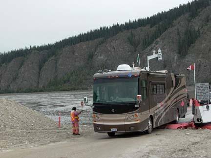 It was not so much the dramatic high peaks and snowcaps that you envision, but it was vast mountain ranges that went as far as you could see in any direction. The highest summit was 4515 feet. We crossed it about a mile south of the border crossing. We crossed into the United States at Poker Creek Border Crossing, which is the Northern most land border entry into the United States. The crossing, thus the Top of the World Highway is open from mid-May until the end of September. It is so isolated there that I’m sure that the people who work there must live there for the months which it is open. Several of our group really complained about this part of our trip. I would not have passed it up for anything, even though we did have four rock chips in our windshields to get repaired. We also spent three hours washing on our car and motor home. We got a lot of pictures, but they could never do justice to the view we had from this drive.
I’ inserting this as an afterthought. It really was one of the highlights of the day. We started our trip with a ferry crossing of the Yukon River. I guess the river was between a quarter and a half mile wide. The ferry would only hold two RV’s at most. It took us about three hours to make the crossing, so we were really spread out in this days travel. It was kink of tense driving that big vehicle onto and off of the boat.
Once we reached Jack Wade Junction, we had 96 miles to Tok. Eighty- five of those miles were on the Taylor Highway, which worked its way down out of the mountains into a huge valley where Tok is located. Took originated as a work camp for the construction of the Alaska Highway. I think that one of its major industries now is dogs. I guess they raise, train and race led dogs. It is a small town and the dog population is about double the Human population.
Our first town after we got into Alaska was Chicken. The miners who founded Chicken wanted to name it Ptarmigan, but they did not know how to spell that so they settled for Chicken, which in the North is a common name for Ptarmigan. Chicken’s most famous citizen was Ann Purdy, who wrote a book entitled TISHA. It was about her life in Chicken as a young schoolteacher. We did not buy the book but some of our group did. I guess it is quite entertaining
 .
.In the area of Chicken, there was gold discovered before the strikes in the Klondike. In 1895 the first strike in this area was make in Franklin Gulch on Fortymile River. The Lost Chicken Hill Mine on Chicken Creek is on of those early strikes. While traveling through this area and for many miles West of Chicken we drove through a burn area where 1.3 million acres burned in 2004. Our Wagon Master said they saw the fire when they passed through here last year. We saw some fires in the mountains along the border this morning.
After Chicken, the Taylor Highway is mostly straight, downhill and well paved. I really made up for our slow climbing drive of the morning. For a lot of the trip we probably got between 12 and 15 mpg on our fuel. We got to the Tok RV Village and found good wide pull-through sites with 30-amp electricity, good water and sewer. We had cable and Y_FI, which we did not use because it was $8.95 for the night. We will just wait until we get to Fairbanks.
![]()